Last year I was channel surfing and landed on Channel 18, Boynton Beach’s public access cable channel. The station was airing a film on Boynton Beach’s history produced in 1980. In it they mentioned that where the Leisureville community stands today, Lake Boynton once stood.
How could a whole lake disappear? I started my quest to find the lost lake and found that not only was Lake Boynton lost, but a whole chain of lakes that stretched from Lake Osborne south all the way to the present day Woolbright Road were gone.
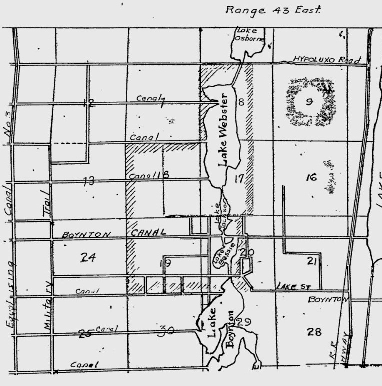
My first clue was this map scrap from 1925, listing all the Boynton Lakes – Lake Webster, Lake Jackson , Lake Bessie and Lake Boynton.
So where did the lakes go? A September 21, 1980 article from the Palm Beach Post helped fill in most of the details. In 1916, the canals on the map above were dug by the Lake Worth Drainage District to help make the land more attractive for agriculture and dairy farming. Boynton Beach was to become the main dairy lands of Palm Beach county, and draining the land helped that process. C. Stanley Weaver was interviewed for the Post article. The Weaver family moved to Boynton in 1910 and owned over 1,500 acres of land in the vicinity of Old Boynton Road, Military Trail and Lawrence Road and were in the dairy business. Mr. Weaver told of the time when the lands around Lake Boynton were hunting grounds for quail and dove and that swimming and fishing in Lake Boynton were popular with all the kids. By the time he returned from World War II, additional drainage canals such as the El Rio Canal has drained away all the lakes, including Lake Boynton. The land changed hands many times before finally being developed in 1968 as Leisureville. The muck was removed from the land and fill added to provide stable home sites.
So what stands today on the land where the second largest lake, Lake Webster? I made a very crude overlay map
Everything lined up perfectly including the small drainage canals that still exist. Much of what was Lake Webster is now the High Ridge County Club and the Quantum residential communities south of Miner Road, but this shows how very large the lake was, compared to the small runoff lakes that dot the communities in the picture. I am sure no one who lives in that area realizes they are living on an old lake bed.
In old newspaper ads from the 1920s, the land was being sold from anywhere from $400 to $2,000 an acre. An ad from October 29, 1925 offered the 850 acres around Lake Webster for $2,5000 an acre. That sounds pretty inexpensive today, but was an incredible sum of money at the time. The 1928 Hurricane brought all the land speculation to a halt. I would guess that in the 1930s or 1940s, the land could have been bought for less than $100 an acre. As we all have learned in the last few years, land and housing busts can happen suddenly and last a long time.


Ginger,
I love the research you have done on Boynton’s missing lakes. The original 1980 history of Boynton Beach film documentary resides in the archives of the Boynton Beach City Library.
I used to live just a couple of miles to the west of where Lake Webster used to sit. The community that consumes the western side of Lake Webster is called “Boynton Lakes”. After reading your research, I now see the reason it is called “Boynton Lakes”.
Thank you for this information. You are an incredible researcher and I appreciate the time and effort you spend discovering these facts about my hometown. I never knew the story of the lakes in Boynton until now and this explains everything. Very interesting as always!
Thank you for your research. I just found out my home is lays on an old lost lake bed.